Basic geological cartography
Currently 151 basic geological maps have been lifted and edited, which represents 83.4% coverage of the country (without the erg).
They are distributed as follows:
- Geological maps 1 / 50 000 :
- 93 published maps
- 17 minute maps
- 07 lifted maps
- 04 unexercised maps
- 05 in progress maps
- Maps 1 / 100 000
- 29 published maps
- 04 minute maps
- 02 in progress maps
- 19 unexercised maps
Synthetical geological cartography
Currently the status of geological mapping at 1/200 000 is detailed as follows :
- 11 published maps
-
04 minute maps
-
03 in progress maps
-
12 Unexercised maps
Mapping of useful substances governorates
The National Office of Mines, produced studies of the potential useful substances in tunisian governorates.
These studies in scale 1 / 200,000 characterize the quality of materials and substances (sands, clays, carbonates, gypsum, etc.)
and define their geographical distribution, their reserves and their main areas of use.
Currently 17 studies covering 19 governorates divided and detailed in the following table:
| Geographic area |
Map |
Report |
Technical datasheet |
| North-West (governorates: Kef, Jendouba, Beja, Siliana) |
• |
• |
• |
| Central-West (governorates: Kairouan, Gasrine, Sidi Bouzid, Gafsa) |
• |
• |
• |
| North-East (governorates: Bizerte, Nabeul, Zaghouan, Ariana, Manouba, Ben Arous, Tunis) |
• |
• |
• |
| South (governorates: Mednine, Tataouine, Tozeur, Kebili) |
• |
• |
|
| Governorate of Gabes |
• |
|
|
Gravity geophysical coverage
The number of cuts in the scale 1/50 000 covered by gravimetric measurements on the ground using a one station per km unit is 93 measures reaching a total of 48 324 measures, representing about 51% from the coverage of the National territory. The year 2020 will be devoted to the studies of the zone Kerker and O.Cherita which are part of the CG11 campaign dedicated to cover the Sahel region
Inventory Basic geochemical multi-wide 1/50 000
The inventory program geochemical strategic concerned 83 cuts of 1/50 000 making a coverage rate of approximately
92% interest in mining areas north and central country.
The Minerals : The industrial rock
Currently, Tunisia holds about 350 industrial careers and more than 400 craft careers
Foreign mining companies operating in Tunisia in the field of mineral exploration
|
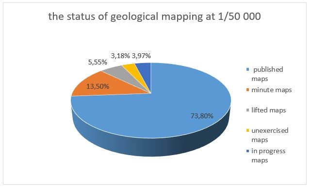
Basic geological cartography : 1/50000
(Larger image - click here)
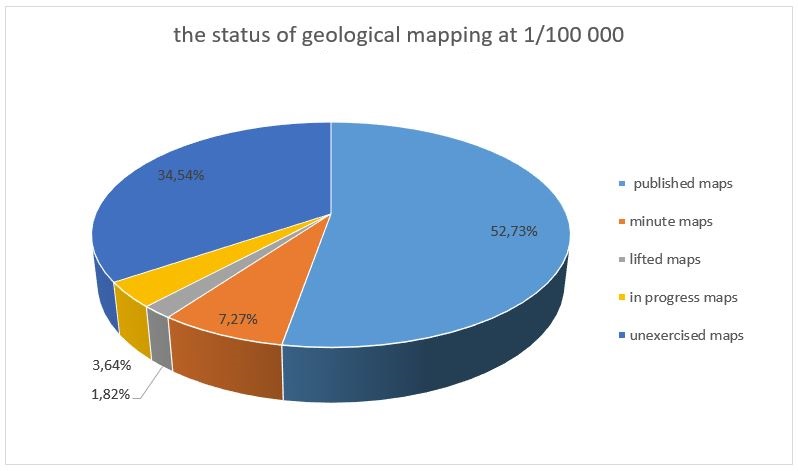
Basic geological cartography : 1/100000
(Larger image - click here)
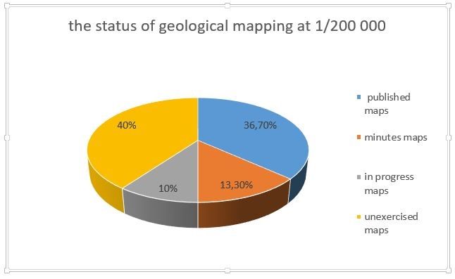
Synthetical geological cartography :
1/20 0000
(Larger image - click here)
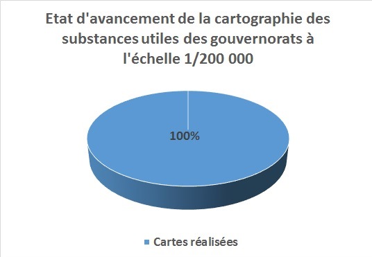
Mapping of useful substances governorates :
1/200 000
(Larger image - click here)
|