|
The NOM has approximately had 48324 gravimetric points covering the country’s north and center regions in a kM2-per-station rate. The gravimetric data are available as a database that encompasses data of raw and treated measures. Gravimetric maps (Bougeur anomaly, residual anomaly, vertical gradient, analytic signal, second derived and regional anomaly are also available in different scales.
Objectives
Recognizing the big structural traits (fault, platform deformations) and detecting the possible intra-sedimentary structures (volcanic coulees, batholiths, salt domes…).
Methodology and precision
- Standardization of the gravimeters between three bases with an interval inferior than 0, 02 mGal for 2 comings-returns.
- Setting up work-base network with an interval inferior than 0,02 mGal per liaison for two comings-returns.
- The measures are to be done in 5-hour programs. The derivate of the gravimeter per hour is inferior than 0,05 mGal.
- The positioning of the measuring stations is realized using GPS receivers with an accuracy inferior than 0.1m.
- The interpretation accuracy of the gravimeter is of 0.01 mGal.
- 10% of the measures are done in G, X, Y and Z.
- The required accuracy on the gravity, planimetry and altitude are respectively inferior than 0,02 mGal, 0.10m, and 0.10m.
- The terrain correction is realized up to a 21-km radius.
- The accuracy in the Bouguer anomaly is of 0.1mGal.
|
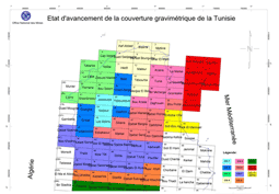 Gravimetric cover
(Larger image - click here)
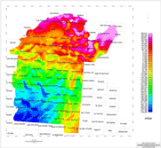 Bouguer anomaly
(Larger image - click here)
|