|
The projects of developing the country’s basic infrastructure do require a deep knowledge feo soil and subsoil and especially natural resources: mineral substances, water… etc
So as to reach these goals the NOM has launched specific programs since 1990, which target the establishment of :
-
Governorates’ maps of useful substances
Objectives :
- introducing Tunisia’s systemic inventory of the non-metallic useful substance in the form of map files in 1/2000000 scale.
- Endowing Tunisia with a database about useful substances (sand, clay, betonies, gypsum…etc)
Elaborated documents:
- Governorates’ maps in 1/200000 scale of the useful substances.
-
Gravimetric maps
Objectives
:
- Providing the national territory with a gravimetric coverage.
- Elaborating databases for all the raw gravimetric measures as well as the treated ones.
- Putting this database and maps at users’ disposal in a variety of domains (mining-research work, natural risks, petroleum research, and civil engineering).
Elaborated documents
:
- Multi-scale maps (1/50000, 1/200000, 1/500000) that elicit six types of anomaly: oguer, regional, second derivative, vertical gradient and analytic signal.
- Gravimetric and georeferential database.
-
Geochemical maps
Objectives :
- Endowing the national territory with a geochemical coverage.
- Elaborating a database for all the geochemical measures, raw as well as treated.
- Putting this database and the geochemical and referential maps at users’ disposal in a variety of domains (mining research work, natural risks, petroleum research and civil engineering).
Elaborated documents
:
- Mono- and multi- 1/500000 maps for the geochemical anomalies.
- Geo-chemical and referential database and mono-/pluri- elementary graphic documents in different scales.
-
Natural-risk maps
Objectives :
- To draw seismicity, flood, erosion and desertification maps for the purpose of risk prevention and security measures especially in the most vulnerable areas.
- To create mid- and long-term-data files that encompasses natural risks.
- To set up a national database on the different natural risks that occurs in the country.
Elaborated documents
:
- Thematic-natural-risk maps: landslide, seismicity, inundation, erosion, desertification… etc
|
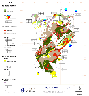
maps of useful substances of Siliana governorate in 1/200000
(Larger image - click here)
|