|
Each country has had its peculiar vagary, which is relative to morphology, geology, regional contexts, climatic factors and human activities.
In Tunisia, the natural risks can be subdivided into four domains :
- Risks that are related to littoral and continental plateau.
- Risks that are relative to land movements.
- Risks that are relative to inundations.
- Risks that are relative to desertification.
During the last five years, the NOM has started working on vagary study that can give rise to risks. For this endeavor, it has fulfilled the natural-risk map of “grand Tunis” in order to help set up a preventive strategy,
Risks relative to land movements (seismicity and landslides) :
The data collection of instrumental and historic seismicity and recent or actual indices of the earth crust have allowed the implementation of security measures in the vulnerable areas to the seismic and landslide risks.
Grand Tunis’ map of natural risks :
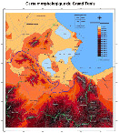
This map elicits risks that are relative to inundations, seismicity as well as landslides. It is accompanied by many data files, which provide scope for the orientation and implementation of security measures in the areas that are exposed to those risks.
|

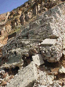
Instability of the road Korbous
(Larger image - click here)

Morphological map of Greater Tunis
(Larger image - click here)
|


