|
At the beginning of the 1980s, the incontestable shortage of synthetic-cartography works fuelled much interest in the geologic service to implement programs for the purpose of drawing those maps.
The Exhaustion of G. Castany’s (1951) second edition of geological map in 1/500000, which is composed of two breaks (north and south), extending to the west on the Algerian territory and accompanied by a 143-page illustration and 14 plates, enticed the geologists Mr. Ben Hadj Ali and al. from the geological-service Department in 1985 to fulfill the third edition of the geological map in 1/500000 in three breaks (north, center and south).
The provisional geological maps in 1/200000 are exhausted too, for this reason an updating program aimed to create a new geological coverage in 1/200000 scale was executed.
|
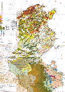
Geological Map of Tunisia
(Larger image - click here)
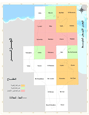
Board assembly
Geological Tunisia 1 / 200 000
(Cutting UTM)
(Larger image - click here)
|